Showing posts with label sightseeing. Show all posts

Tuesday, November 13, 2007

The Glaciers and Wanaka (Part 2)


[Note: This is part 2 of 2. Go here for part 1.]

Franz Josef glacier was just awesome. There's nothing else to say about it. What was also really awesome, though, was the valley the glacier was in - it had a ton of places to climb on, over and in. We saw glacial striations on the rocks - marks that are gouged into the rock by the moving glacier - and even two excellent outcrops (here and here) of a small fault (waterfalls/streams are great candidates for finding faults). We walked right up to the glacier itself; there were stairs going up it for the guided (read: paid) tours. After checking out the sweet river coming out from the bottom of the glacier - it struck me as something coming out of the depths of hell, albeit an icy hell - we were forced to head back by the inevitable rain.

Just a half hour drive south, we saw Fox Glacier. Once again, very, very cool. Andrew, Mary and I made the short walk out to a good lookout - no need to go right up to it, once you've seen one glacier, you've seen 'em all, right? Ha! In the picture, you can sort of make out the layers of snow and dirt going across the glacier, especially dipping in the middle where the river comes out. Nice.

That day, we drove 4 hours back to Wanaka, both because we didn't want to drive 8 hours home to Dunedin in one day, and also because it was Andrew's 21st birthday, so we wanted to be somewhere a little more amenable to fun, namely a BBQ. The drive, like all of the drives on this trip, was stunning, particularly Lake Wanaka, with its turquoise blue water. Shadowfax - Carrie's trusty steed of a Toyota Corona - was really in her element here. The hostel we had was right in town and had a grill, so we were all set. Sausages, portobellos, peppers and cucumbers - a veritable birthday feast!

The last day, Monday, we woke up to more gorgeous weather, and in Wanaka that can mean only one thing: Puzzling World! We were quite ready to be a-MAZED, so we made haste. This wonderland has two main attractions: a series of 'illusion rooms' and a huge outdoor maze, which can take up to 2 hours to finish if you try the hardest method. The illusion rooms were great - highlights included a room of scowling faces like Ghandi, Churchill, Lincoln, etc. which appear to follow you as you walk around with one eye closed, an Ames room, which makes you look alternately huge and tiny, and a tilted room where balls and water moved uphill, and you can stand 'askew,' as it were. NUTS. And yes, we did the maze (albeit with some cheating).

So, all in all, it was a magnificent trip. We drove about 1,400 km - 870 miles. The oil-guzzling, WOF-free Shadowfax handled it like a champ, and we saw some incredible stuff. Best to go out on top, I say.

Kepler and the Glaciers (Part 1)

[Note: This is part 1 of 2. Just trying to keep it readable. Find part 2 here.]

This post is long-delayed for a myriad of reasons, among them my last final (it went as expected, which is to say it was easy and stupid), post-finals celebrations, and now packing to get ready to leave in a ridiculously short 36 hours. But I'll save my thoughts on that for another post...

Anyway, the road trip I took was, without a doubt, one of the most incredible things I did in my time here, and certainly ranks near the top of my list of favorite experiences ever (right up there with - among other things - getting on TV at a Red Sox game, speaking at my middle school graduation, Thanksgivings at Zin's, and spring break '07 at Lake Tahoe).

We started early on Friday morning, and with a healthy breakfast of a mince pie and V, we were off. Our first real stop was on the Clinton-Gore Presidential Highway - no joke. The sign is located, not surprisingly, on the road between the small towns of Clinton and Gore. No, NZ doesn't have presidents, and yes, these town have been around for a long time. Surprisingly, there's not much information online about this, but one plausible explanation says that it was named this in 1999 in when Clinton came to NZ for a meeting, and that a replica lives in the presidential library in Little Rock. Who knows?

We started the Kepler track in the early afternoon, and took down the first section (14 km, ~9 mi) in four hours, which is pretty good considering the 3,200 ft vertical on that part of the trail. Like I mentioned before, the extreme alpine conditions beyond Luxmore wouldn't let us go on, but it was still spectacular. Luxmore Hut was really nice, particularly the mattresses in the bunks, and even better, the sweet cave and views 10 minutes from the hut. Good times.

The next day, we hiked back out (after probably sleeping later than anyone ever has at that hut) and let me tell you, there is not great feeling than taking your boots off after a solid hike. From there, we drove a solid 513 km, which is only 320 miles, but on country roads that are often windy, it can take some time. It was a great drive (I got to get behind the wheel - see me in the zone above) and driving along Lake Wakatipu and then the Crown Range to Wanaka was something I won't soon forget.

We got to Franz Josef that night, and pretty much immediately crashed (having survived the trip on potato salad, cheesy poofs and potato chips). The next day, Sunday, I woke up a while before everyone else, so while I was entertaining myself on the hostel's porch swing, all of a sudden Nick, a student from Bowdoin in my geology class, walks outside! Turns out he was traveling around alone, so after my genius idea of making eggs and bacon (Kiwis eat all kinds of weird bacon, so for future reference, look for 'streaky' bacon in Commonwealth countries), we all drove out to Franz Josef glacier.

Wednesday, November 7, 2007

Epicness

Well, I've been itching to post something about the trip to Kepler Track, the glaciers and Wanaka, but I don't have all the photos yet (I need to get some from friends), so I'll just post a few samples of what we saw now, and follow with a full post (probably) tomorrow. Also, check out the full album of what I already have to the right (or here); I also put my pictures from the trip to Qtown with Andrew into the Queenstown album.

Walking to the terminal face of Franz Josef glacier. We're about a 20 minute walk from the wall of ice, to give an idea of size.

Throwing caution to the wind.

On the drive from the West Coast to Wanaka.

Our BBQ feast for Andrew's 21st bday. I pierced the sausages too early, clearly.


And finally, us enjoying the optical illusions at Puzzling World in Wanaka. If I were smarter, I would've recorded this with my camera parallel to the floor, and not truly level. Oh well.

Thursday, November 1, 2007

The Game Plan

So about a month ago, Andrew, Carrie and I decided that during finals we should do a tramp on one of NZ's Great Walks. Since I've never explained them before, briefly, they're a set of tramping tracks on the North and South Islands, managed by the Department of Conservation. Each track has well-maintained tracks and huts spaced about a day's walk from each other, meaning it actually costs quite a bit, usually $40 per hut. They have a booking system, too, to keep pressure on the tracks to a minimum, so really popular tracks like the Milford and Routeburn fill up fast. This brings us to the tramp we planned on: the Kepler Track. It was actually built in the mountains near Te Anau to alleviate pressure on the Milford and Routeburn, and is really nice - particularly the second day of the tramp, which is almost exclusively walking along alpine ridges.

Unfortunately, it's that ridge line that's caused us problems. We were going to do the track this weekend, but because of some late-season snow, crampons and ice axes are required, which is something we can't really muster right now. So briefly, the outline of our fly-by-the-seat-of-your-pants plan:
  • Go to Kepler, and hike the first (passable) section, and stay at Luxmore Hut Friday night.
  • On Saturday, hike out and make an epic, beautiful drive to Haast and the West Coast, and stay in a hostel.
  • Sunday, we'll go to the glaciers at Franz Josef and/or Fox, which are the most accessible glaciers in the world. At the same time, we should get a great view of Mount Cook across Lake Matheson. Maybe camp out Sunday night, and head back to Dunners Monday.
Cool, eh? It's gonna be great. Cheers.

Qtown Redux

Sorry for the delay, but I couldn't post this without pictures. Queenstown was fantastic, as to be expected. A few notes:
  • We stayed in an incredible condo with views overlooking Lake Wakatipu. Many thanks to Andrew's parents for putting me up, of course. Amenities abounded, including a fireplace, heated tile floors and towel racks in the bathroom, bathrobes, and most importantly at the time of our arrival in the afternoon: satellite television, which meant, of course, I could watch a little of the Red Sox owning the Rockies in Game 1. That made me happy, particularly since Andrew and his parents put up with my excited delirium at the Sox doing so well.
  • My second trip up the Skyline Gondola on the hill/mtn. above Queenstown was really nice, once again. The weather was picture perfect.
  • There's nothing better than waking up in the morning and sitting outside in the sun with a cup of tea and a good book, with the expansive Lake Wakatipu and Remarkables towering in front of you you.
Easily the highlight of the trip was going to dinner at a smaller restaurant on the (relative) outskirts of town, recommended by a local. It's called Vknow Restaurant (a well-deserved name) and if there were ever a restaurant I would recommend to someone visiting NZ, it's this one. It's owned and operated by a husband and wife - he serves and handles wine, she's the chef. Even though the husband handled a full restaurant of about 30 people by himself, the service was exceptional and attentive. Throughout the several courses of our meals, he would come by with a different wine that best goes with the particular course - I can easily say I've never enjoyed or appreciated wine as much as I did that night. The wine list was clever, too, organized into sensible categories by quality. For those may know NZ wine, we had Quartz Reef Pinot Gris, Ngatarawa Silks Chardonnay, Akarua Rose, some Bollinger NV with desert, and I believe there was one other wine...maybe a Cabernet Sauvignon? I'm not sure. Regardless, a great night with some delicious food and fine wine.

Sunday, October 7, 2007

Best. Billboard. Ever.

I've never been the biggest billboard fan. After all, I grew up in one of four states that prohibits them - Alaska, Hawaii and Maine are the others - and I was pretty glad that the gaudiest sign I had to look at growing up was this one, but mostly just because it meant I'd crossed the river into West Lebanon, a bastion of congestion and commercialization.

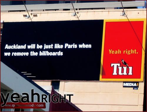
Anyway, I've had to change my ways since going to school in L.A., obviously, and I can appreciate good advertising, which leads me to this incredible billboard. It's just two blocks south of my flat, on the side of the main northbound road through Dunedin, outside 'The Bowler,' a bar, and Video Ezy, a movie rental place.

I love this sign for a number of reasons, but it's mostly because it just has so much going on, on either side. The older ad on this sign is for Tui, a brewery from the North Island that makes what's probably the second-most popular student bar beer here, next to Speight's (a Dunedin brew, see more here). As a beer, it's alright, although I've got to admit I've never seen anything other than their East India Pale Ale. It doesn't matter though, because they've got the best advertising campaign I've seen - the left side of the ad has some 'rational' phrase or declaration, simply white text on black, and to the right, 'Yeah, right.' It's hilarious, simple and effective, especially since they cater to the area they're in - hence the flatmates statement. To add to the greatness, don't miss the graffiti below it too.

The newest addition to this board is on the other side. Actually, it's more of an alteration, but an extremely timely one that gives it a whole new dimension. For some more back story on this, go here, but just as soon as the riots happened, the Bowler plastered this gem up. Not really much more to say about it, but for those here who know about the riots (that would be everybody) it's fantastic. Doesn't make me want to go to the Bowler any more than before though - it's probably the #1 or 2 destination for Dunedin high schoolers on weekends. Blegh.

Sunday, September 23, 2007

Milford Sound

That would be Mitre Peak, probably the most photographed mountain in New Zealand, towering over Milford Sound. Holy crap, you can see why. See my heaps of photos here.

So the Butler program took me and pretty much everyone else out there last weekend for our 'adventure weekend,'--probably the best use of the money we pay the program. We rolled out for Te Anau on Friday, staying in a hostel in town. We started Saturday morning by going across Lake Te Anau to the Te Ana-au Caves, which are a far more accessible kind of glowworm caves, compared to the sweet-as (only one 's', yes) ones we saw in Greymouth. It was cool seeing different caves (these were limestone vs. sandstone) and there were tons of glowworms, but walking around on platforms just doesn't have the same coolness factor. Oh well.

After that, we started heading up the two-hour drive to Milford Sound. It was an epic drive, with mountains shooting straight up on either side of the road - I was straining my neck to look up and out the bus windows as best I could. Finally we got to the sound itself, just a dead end road with a bus terminal/boat dock with a half dozen cruise ships moored outside. The picture at the top is what we saw just before we got on the ship.

We weren't on the ship for more than two minutes before we saw our first waterfall, and it was the first of dozens...I couldn't even keep track, because the number of falls fluctuates depending on how much rain they've gotten recently (and there's always a good chance of that, with about 23 feet of rain a year). That waterfall is in the picture here with the red New Zealand flag, used on nautical vessels for whatever reason.

There was SO much to look at on this cruise. The fiord (if that looks funny, it's because most other places spell it as 'fjord') is almost 10 miles long, and has sheer rock faces coming out of the water on either side, 4000 feet up. On the creepy side, those walls go pretty much straight down too, about 1600 feet below the surface.

Of course, all of this spectacular scenery is thanks to the glory of geology in action. In the last couple ice ages, this region was heavily glaciated, and carved into a U-shaped valley, the way it is today. Obviously, there's a lot of evidence for it left. Among the cooler things were the gouge marks in the walls of the fjord. In this picture, they're the lineations going down and to the right, meaning the glacier flowed from left to right, towards the ocean.

Also quite awesome were the many hanging valleys around. These form when you have a smaller glacier flowing from higher up into a larger glacier. The small U-shaped valley, after the glaciers recede, end up sitting above the large valley, often with waterfalls flowing out of them. I just love the perspective of looking up and into one of these valleys, like the picture below, which gives you an idea of the sheer scale of these things.

Okay, okay, enough geology for now. After our sweet cruise, we went back into the dock and were boated out to another cruise ship, anchored in a nearby cove. The ship we got onto was the one we were originally supposed to cruise around on too, but apparently they may have hit some rocks when they got to close to this waterfall - something they usually do all the time. Anyway, this was the ship we were sleeping on for the night. Our group had cabins with two beds in each room - a sweet deal - but by far the best part was the buffet dinner we had that night. I'd forgotten what a huge, delicious, multi-course meal was like.

In the morning, we got a real taste of the sound, when me and 5 others got up at 6:30 and jumped in the water. It seemed like a terrible idea at the time - the anticipation was awful - and once I hit the water, I couldn't decide whether if felt like my skin was burning or freezing. After a frantic doggy paddle over to the back of the boat, I thought it would be a perfect complement to my impending frostbite to jump in the water again. While it may sound like suicide, from the point I got in a hot shower afterward, I was really glad I'd done it. After some kayaking around the sound, we headed for home.

Now, we would have gone for a little hike on our way home, but of course, it was raining. I have the pictures to prove it. Instead, we made for Dunedin a little earlier, but I think getting back to the city at this particular time, just to happen to see this, was worth it, don't you? I'll leave it at that.

Wednesday, September 19, 2007

The Last Leg!!

YES...my last post about MSB. It's about time. Now let's get on with it!

After we left Golden Bay, we went east past Nelson to a little town called Havelock. We basically used Havelock as a stopover point between Golden Bay and Kaikoura, but it has the added bonus of being right on the Marlborough Sounds, on the northeastern part of the South Island.

Like pretty much every other place we'd been on this trip, the Sounds were fantastic, and we had a great, windy drive along them on the way to Kaikoura, our next major stop. The shot above is from the Queen Charlotte Drive, a really picturesque road between Havelock and Picton.

We got to Kaikoura in the early afternoon, and man, what a town. I immediately regretted the fact that we were only staying there for the night, just from the view we had from the deck of our hostel, as you can see.

This hostel (Dolphin Lodge, for those keeping track/keen on going to NZ), was fucking fantastic. Honestly. It was a pretty nice big house, on a hill above the main part of town. Obviously, great views. There was a hot tub AND a grill on the deck (along with a picnic table), a hammock, and two housecats to keep us company. Not only all this, but we were practically the only people in this entire house (save for one other random student), and we loved it so much we recommended it to our friends who were passing through, so it was a regular party.

There was definitely enough to do in and around Kaikoura for two or three days, but with one day, we weren't sure what we could do, so we call kinda split up and did our own things for a little bit. Andrew, Kelsey and I decided to go out to the tip of the peninsula and go for a walk/hike, especially because we heard about a seal colony there, and most importantly, wicked cool rocks. Anyway, once we got out there, the weather got bad really quickly. In fact, it was the worst weather we'd had all break: dark, ominous clouds, rain out in the distance, and some of the hardest gusting winds we'd ever felt. Of course, this actually turned out to be one of the coolest things we did on the trip. Andrew, Kelsey and I basically all did our best to stand against the wind--they both put their jackets over their heads to act as windcatchers--and you can see the kind of stuff they could do. It was a blast taking pictures of this. The next day, Andrew and I and the friends we met (Carrie and Steph) went biking to a breakfast place, while the rest of the bunch went on a 'swim-with-the-dolphins' cruise. Turned out they didn't swim with them though - there weren't enough of them. Bummer!

Alright, I'm going to roll our last to places into one, for brevity's sake. After the night and breakfast in Kaikoura, Andrew and KC left in Carrie's car to actually go back to Golden Bay so they could do fun stuff in Abel Tasman National Park with the Arcadia study abroad program. The rest of us drove on to Hanmer Springs, a couple hours away. It's a little town near the mountains (not IN them, as their tourist ads may lead some--me--to believe) with natural hot springs that have been piped into a resort run by the town, full of pools of various temperatures. Other highlights: the coolest mini-golf/temple maze (though they are separate courses) place ever, and the 'on 47 Bar & Grill'!!! I need to send this to Pomona, clearly.

The last night of our trip, we drove down to Christchurch (completing the contrived, tourism-conceived Alpine Pacific Triangle). We stayed at a hostel really close to Cathedral Square, the center of the city. We basically spent our time walking around the various markets (leading me to a great purchase - $10 mirrored Aviators) and the Canterbury Museum--home of sweet old-fashioned bikes, among other things.

Alright, that wraps it up! It only took me about 3 weeks to do, so not bad, right? Hopefully soon enough I'll put up pictures and talk about my trip to Milford Sound. Let me just say, it was something. Cheers!

Monday, September 17, 2007

Golden Bay

Here's an ironic little fact that I just realized: I don't think that I have a single photo of Golden Bay, out of the 100+ pictures I took over the 3 nights we spend in the area. How does that happen?

So we stayed at a pretty nice Backpackers called Annie's Nirvana in a little town called Takaka (after weeks of pronouncing it ta-KA-ka, we learned from Simon that we were butchering it, and it's actually TA-ka-ka). The town and Golden Bay in general were pretty full of hippies and their culture, almost reminding me of home - if home also included sheep, rolling grassy hills and snow-capped mountains. Wait.

Taking full advantage of having a sort of base camp for three whole days, we got to make a lot of trips all around the area. Our first one brought us north of Takaka for an hour round trip hike to the beach - we'd heard that this was prime season to see seals (and baby ones too), but we didn't have any idea how lucky we'd be. First we saw about half a dozen young seals playing in a freshwater stream, probably a couple hundred yards from the beach. It was pretty strange seeing seals outside of the ocean, but apparently it happens.

The beach there was really cool, with a bunch of variously-sized dunes there for the climbing (and jumping). Out by the water, we ran into even more seals, this time frolicking in good ol' salt water. I've never taken more pictures of wildlife, but I think it was worth it; these seals were literally 10 feet away, seemingly oblivious to the 5 or so people just standing watching them - I couldn't believe that we could just walk right up to a beach with a bunch of seals (including pups) and not have anyone there to regulate how many people go to that beach, or how close they get to the seals. For the record, I love this. More later. And check out the adorable, makes-you-want-to-puke Kodak moment below for the seal pup.

We did a little shell-collecting too, and found some really cool little spirally white ones that looked like this. At first glance, with their chambered shells, they look like they could be nautiluses, but a little Google sleuthing led me to Spirula spirula, a sort of squid thing.

Annnyway, the rest of the day we spend taking other little hikes near Cape Farewell, the northernmost point on the South Island. To get to the actual point, we basically just parked our van at the end of a little dirt road, and walked over a few hills full of sheep - clearly this is a famous spot. My sarcasm shouldn't degrade the place's beauty, though. Farewell Arch was really cool; besides being generally awesome-looking, the cross-section of the hillside revealed some sweet geology. Looking at the picture, you can see layers of sedimentary rock sloping toward the bottom right, with alternating layers of conglomerate (darker) and sandstone (smooth and light). If you ask me, this represents a depositional environment with changing sea levels, from lower (conglomerate deposited by rivers) to higher (sandstone from the beach/intertidal zone).

The next day we spend exploring another area near Golden Bay, this time going for a hike through the sub-tropical forests along a stream. The trailhead was on the edge of the forest and farms, specifically next to a little snack bar/shop called 'The Naked Possum.' What a quirky place: the outdoors cafe was furnished with a fireplace and large pieces of nice wooden furniture, while just across the driveway was their shop dedicated to selling all things made of possum fur. Also of note, the best meat pie I've ever had: homemade wild venison and wild mushroom, with a plum sauce on the side. Heavenly.

The last couple things we saw were just incredible. On our last day in the Golden Bay area, we first headed to Rawhiti Cave (pronounced Rafiti). All we knew before going was that it's the largest cave opening in the Southern Hemisphere, but to get there, once again, we were driving through farmland, following little signs, which made you wonder...how big could this really be if we have to drive down these little roads just to get there? Well let me tell you, it was HUGE. After a grueling hike up the side of this hill (which we didn't expect) we were blown away at this thing. It was probably 40-50 yards across, and 40-50 feet tall, at the entrance. From there, the cave slopes down steeply into the hillside, but doesn't go very far. We climbed down a little ways, and you can see from the picture how many stalactites ('tight to the ceiling') and stalagmites ('they might reach the top someday'). And of course, this cave is actively forming, as you can see from the steam and water splashes in the picture. Awesome. After the cave, you'd think it couldn't get much better, but it certainly did. We made a nice little drive along the bay to Wainui Bay, a smaller bay within Golden Bay. Holy crap, just look at the pictures to see how beautiful it was there. Not only was the water super blue, and the sky clear and sunny, but the tide was low enough so we could go out on the rocks on the beach and just enjoy the view. To the right is Whariwharangi Bay, at the start of the Abel Tasman Coast Track, one of New Zealand's Great Walks. Also of interest here was that the rocks changed...to those who care, before in Golden Bay we'd already seen sedimentary rocks (pictured at Farewell Arch) and metamorphic rocks (which we saw near the Naked Possum), but here was a huge granite--that would be igneous--outcrop! Crazy stuff.

For fear of being way too long-winded, I want to quickly follow up on something I said before, about regulation. From this trip, particularly our stops by the seals and Rawhiti Cave, if I've learned one thing, it's that New Zealand does not regulate what people can and cannot do in nature. That's not to say littering is legal--far from it--but rather that in situations where people are confronting unique flora and fauna, like the seals, or adventurous activities, like going in the Rawhiti or Dragons Caves, the onus is on you, the observer or tramper, to make the judgment that you think is correct. Your safety, and nature's, is in your hands to do with it as you wish. And people here take this seriously; New Zealand has an adventurous, outdoorsy society, but not a litigious one, for which I'm very thankful. That's all.

Friday, September 14, 2007

Me = Bad Blogger

Okay, I'll admit it, I've been a bit lackadaisical about posting recently, but how can I be blamed? I wrote two papers this week, and had a bunch of reading to do for a tutorial. That's fair, right? Right.

Anyway, I'll continue the mid-semester break posting again next week, since I'm going to Milford Sound this weekend! It's in Fiordland, one of the most beautiful places on the South Island from everything I've heard (Andrew went there about a month ago and called it 'EPIC'), and even Kiwis love it, as compared to super-touristy Queenstown. See that link for mind-blowingness. And best of all, this is a Butler trip, so it's free. We're making 5-or-so-hour bus journey to Te Anau tonight, then tomorrow we're going on an overnight cruise on the Sound, complete with food, kayaking and all sorts of other goodies.

So yeah, after the weekend look out for some more posts about MSB and now, Fiordland. Sweet.

Friday, September 7, 2007

Dragons Cave and the Pancake Rocks

The next morning, we got up bright and early. The girls went off for a morning walk, leaving me, Andrew and Kelsey to enjoy the the scenery the Pass has to offer from the front porch of the general store. This is when a trip tradition truly began: eating meat pies for breakfast. It may sound a little weird to many of you, but if there's one thing I've grown to appreciate in NZ (besides polypropylene) it's the glory of a good steak & mushroom pie for breakfast. You can get them at nearly any dairy (convenience store) or diner, and there's always one in even the tiniest villages, and they're really convenient, but I'll move on for everyone's sanity.

We made the drive to Greymouth, on the West Coast, and headed to the Wild West Adventure Company for some blackwater cave rafting, which may have been one of the coolest things I've ever done.

The company really treats you right; we all got lots of polypro to go underneath thick wetsuits, and helmets with headlamps. This is serious stuff. Of course we were making a fashion statement. Next we set off on a tramp through some beautiful woods to get to the cave opening, where we assembled for our last moment of dryness for several hours. Then it was into the cave; I was completely awestruck at how cool it was (you can see me brimming with excitement below). The caves in this area are made from sandstone (imagine the sand on the beach being squished together to make a rock) but a ton of stalactites (from the ceiling) and stalagmites (from the ground), which formed from calcium-rich water drops filtering through the caves. It was a geologist's dream.

We clambered over rocks and through the underground stream for a while, and let me tell you, that wetsuit was a lifesaver in that water. At one point we came to a waterfall that's about a 5 foot drop into a bowl-shaped pool of water below - it was questionable, but of course we each got to go down the waterfall and drop into the pool, then our guide pulled us out and snapped some very flattering pictures of us. We continued down the little river in the cave until we reached a sort of underground slot canyon, which was just wide enough to fit innertubes in. From there, we turned off our headlamps and floated down the stream, reaching a wider chamber where we could see hundreds of glowworms - these are gnat larvae that dangle a dozen or so sticky strands from the ceiling to attract insects, and each worm has a little green spot that glows to attract prey. After enjoying a thermos of hot chocolate that our guide provided us, we headed back out, but not before going through the 'Tunnel of Love,' something that rivals the Lemon Squeezer cave in the Lost River (if you've done that) for space, and easily surpasses it in coolness - the rock formations in there were incredible. Also, we got to do a little hydrosliding on the way back (which reminded me a lot of OA at Yosemite):

The excursion ended with a trip back to the Wild West headquarters in Greymouth, where we got to relax and warm up in a hot tub with complementary beer and muffins (interesting combo). I wish I could say more, but this story is just better relayed in person. And check out the pictures (our guide brought a water-safe camera down with us) to get more of the story.

The big sight for the next day was the Pancake Rocks in Punakaiki, about a half hour from Greymouth. They're just really crazy limestone formations, right on the beach. They look so cool because they're in perfectly parallel layers (in between each limestone layer is a thin layer of mudstone) and erode really cool in the surf. Apparently it's unclear why the limestone would form layers like that (normally it doesn't). Despite the heavy geologic themes of the trip so far, not everyone was as analytical about all of this as Andrew and I were, but we did do our best to impress.

Golden Bay is coming up next. Also, I've put up three albums on Picasa, you can see them to the right. I've got all of the other pictures uploaded, I just have to organize them and give them captions, so that'll happen soon.

Wednesday, September 5, 2007

The Beginning: Arthur's Pass

Alright! I've finally gotten around to posting a little about the trip. I thought the first day was a good place to start. And don't worry, I'm not gonna get all detailed...I'm mostly doing it for some of the pictures.

This first one is from the Moeraki Boulders, which are on the beach only an hour north of Dunedin. We got a bright and early start Friday morning, and amazingly, it was absolutely gorgeous out, so a stop at the beach was perfect. I won't bore you with all the details, but these boulders were always spherical - they're called concretions - so the water didn't have anything to do with shaping them. It just wore them out of the nearby cliff.

Our next little stop was in the town of Springfield, home since July to a giant pink-frosted sprinkled donut. Sadly, there's no movie theatre in this town...a population of 219 will do that. Just goes to show how far the people at the Simpsons Movie were willing to go to promote their film.

Soon we started to climb into the mountains, leaving the terribly flat Canterbury Plains for the Southern Alps. We did well going into the mountains, though, thanks to our trusty rental van...we may have had 7 of us packed in there like sardines, but she was a trooper. All in all we drove just around 1,300 miles in her, and I got to drive almost 1,100 of them. And all but maybe 100 feet on the left side of the road! Not bad.

The village of Arthur's Pass - the highest elevation settlement in New Zealand, at around 3,000 ft - was really cool. Its population is about 50, but it could have been as low as a dozen, since that's all it seemed was necessary to run everything in town - the Mountain House hostel we stayed at, the store next door, the restaurant/tavern across the street, the DoC...not sure what else there was. The hostel was phenomenal, and the manager (who was from Calgary) gave us all a hard time for studying in Dunedin, saying he would turn off the heat in our room and give us puke buckets in our room because that's what us Otago students are supposed to be used to. Crazy.

After we settled into our bunks a little bit, we went for a quick hike to the Devil's Punchbowl waterfalls, a 525 fall. I took this picture at the bottom of the falls, in some of the rapids. I'm a big fan of this one - the sun going down made it come out this way. Incredible. Next up is the Dragons Cave in Greymouth and the Pancake Rocks in Punakaiki.